The City of Roanoke, VA Chooses SiteVision For Geographic Information System Support

Roanoke VA September 9, 2015 — The City of Roanoke, Virginia has contracted with SiteVision, Inc. for ongoing support and enhancement of the roanokecitylogosquareCity’s Geographic Information Systems (GIS). The city’s GIS system is used extensively by the public, as well as by city employees. The firm, together with the city, collaborated to design the original GIS architecture, along with improvements over the years.

The City (http://www.roanokeva.gov) uses GIS to solve problems and improve business processes while promoting enterprise solutions. GIS is a system of computer software, hardware, data, and personnel to help manipulate, analyze and present information tied to a spatial location.

As a veteran in the geospatial sector, SiteVision has been planning, developing and hosting GIS Internet applications since the mid-1990’s. The firm’s experience ranges from evaluating, recommending, and designing local, regional, and state GIS applications and related infrastructures, to developing national systems designed to store and access multiple petabytes of geospatial Information.

SiteVision (http://www.sitevision.com), among other responsibilities, will provide on-going maintenance to all versions of the Real Estate GIS websites. The firm in concert with the city will also assist in customization and development of future website upgrades, server design and software solutions. SiteVision will collaborate with the city’s GIS staff to provide additional technical expertise and recommendations as requested.
.
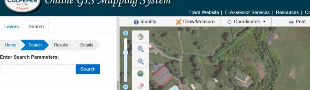
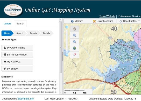
Currently, the City’s Real Estate GIS system offers desktop, tablet, and mobile versions. A comprehensive selection of search tools allows the user to query the City’s real estate system and access detailed property information directly. Community information provides users with a summary of specific neighborhood information such as school zones, voter precincts, trash collection, greenways, and youth athletic regions. The incentive portal provides a summary of city, state and federal incentive programs available to a specific parcel.

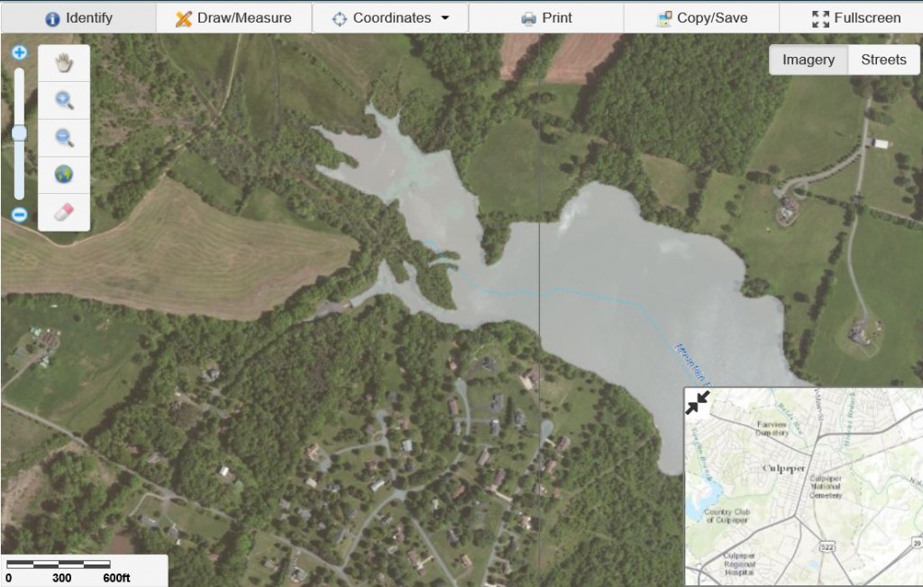
Other GIS functionality includes tools for selecting and drawing spatial queries. Users may access related community and incentive data, create reports, and use links to the city’s permitting center. Google maps and city-owned Pictometry imagery are incorporated. In addition to specific parcel information, the map services include community layering indicating greenways, parks, schools, voter precincts, golf courses, and more.

About SiteVision: SiteVision, Inc. (http://www.sitevision.com) is an Internet application development, consulting, design and hosting firm. The firm provides solutions for a broad spectrum of markets and industries, as well as for state, federal and international entities. Expertise includes custom, dynamic applications, consulting to achieve unique goals, geographic information systems (GIS), and content management systems. Hosting services include shared, custom and dedicated hosting solutions, as well as map and GIS application hosting.

SiteVision, Inc. participates in, or is available through, the following state and federal contracting vehicles, and is an SOC 1 SSAE 16 Type II compliant firm:

The firm’s home office is in Roanoke, VA, with sales offices in Charlottesville, VA and Miami, FL.

###

Town of Culpeper, VA Launches New Online GIS System By SiteVision, Inc.

Roanoke, VA January 18, 2014: The Town of Culpeper, VA has formally launched its new online GIS System (http://townofculpeperva.gisbrowser.com).  SiteVision, Inc. (http://www.sitevision.com) is providing the new GIS system as software as a service (SAAS) under a Commonwealth of Virginia Hosting Contract which is available to all public agencies (local, regional, state), and to other states as well.  SiteVision developed the site to be cross-platform compatible and accessible via mobile devices.

Culpeper, VA GIS System by SiteVisionPrior to selecting SiteVision, Inc. as its SaaS/hosting vendor, The Town of Culpeper GIS and IT Department surveyed the needs of its residents and system stakeholders.  The Town then outlined the necessary and most requested mapping functions, layers, data sources, reports, tools, etc. to be required in their new online GIS system.   

SiteVision first began working with the Town to help establish CAD and GIS data interoperability standards, maintenance procedures, and to create and test related Internet map services.  These initial tasks\services were contracted by the Town to SiteVision, Inc. through the Commonwealth of Virginia’s IT Contingent Labor Contract.

The Town of Culpeper’s new system utilizes more than 30 map services from several sources including SiteVision, Inc., the Town of Culpeper, Culpeper County, Environmental Systems Research Institute, Inc. (ESRI), and the Commonwealth of Virginia.   The Town maintains all of their own GIS and CAD data and uploads their data updates to the new online GIS system at least once a month. 

CulpepperGIS_system2Users may query and access real estate tax and assessment database record(s) and related tax map parcels, download property cards, and view points of Interest (Police, Fire, Schools, etc.) with notes and links to more information.   The user can draw and measure features on the map, locate GPS points or coordinates, and save, copy or print a custom map.  The system also allows users to download reports and tables in Adobe or MS Excel format. 

Culpeper VA GIS 3“We tried to incorporate the most requested new features into the project,” said GIS coordinator Autumn Fitch. “The biggest thing is that it is cross compatible with so many browsers.”  –Star Exponent, Posted: Tuesday, November 12, 2013 12:15 am | Updated: 6:29 am, Tue Nov 12, 2013. 

The overall project stayed within the existing GIS budget with no additional costs to taxpayers, according to the town. –Star Exponent, Posted: Tuesday, November 12, 2013 12:15 am | Updated: 6:29 am, Tue Nov 12, 2013. 

Daniel Shaffer, Director, Geospatial Division for SiteVision, added “With today’s economy, many public agencies are stuck in legacy online GIS systems with no foreseeable way out.  Our SaaS plans allow public agencies to migrate to the latest systems while spending little to no upfront fees or costs. The agency pays for the SaaS service on a flexible monthly, quarterly or yearly schedule.” 

“It was a privilege working with the Town of Culpeper,” said Patrick Maddox, CEO of SiteVision.  “They did a careful assessment of their needs and were highly professional to work with.  The result is an outstanding GIS system designed with the most recent features available.”  

SiteVision, Inc. (www.sitevision.com) is an Internet application development, consulting, design and hosting firm providing solutions for a broad spectrum of markets and industries, as well as for state, federal and international entities. Expertise includes custom, back-end dynamic applications, consulting to achieve unique goals, geographic information systems (GIS), content management systems, hosting services including, map and GIS application hosting, as well as custom and dedicated hosting solutions.  

SiteVision, Inc. participates in, or is available through, the following state and federal contracting vehicles: 

 The firm has its home office in Roanoke, VA, with sales offices in Charlottesville, VA and Miami, FL. 


SiteVision GIS Partnership With City of Roanoke VA Goes Live

[image source_type=”attachment_id” source_value=”5196″ align=”left” size=”Small 150 width” quality=”100″] July 14, 2013:  The new City of Roanoke GIS (Geographic Information Systems) Application is now live and online.  The new implementation developed by SiteVision, Inc. in partnership with city officials, features numerous upgrades, design enhancements and additions to the original citywide mapping and real estate system.  

The technology initiative enhances an already robust application environment while providing important, new state-of-the-art mapping detail, reporting and printing functions.  The effort provides geographic information to citizens and staff through the Internet, desktop applications, databases and mapping products. It is utilized to enhance existing business systems by providing an easy way to view spatial and other data by geographic location.

Roanoke City GIS
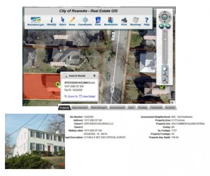
SiteVision and city officials worked closely together to integrate the existing system to the now enhanced version. Among improvements, existing web application servers migrated to the more feature-rich ESRI ArcGIS server and Adobe Flex environments.  New features include floating, pull-down menus to permit rapid switching between various base maps. The redesigned site also includes Google Map and Google Street views. Comprehensive mapping and real estate information includes property overview, images, assessments, sales history, flooding information, community attributes and incentives. Users may also print a full property report including images.  

Roanoke City PortalThe Community and Incentive Website Portals, a useful feature previously developed in cooperation with SiteVision, has been incorporated into the enriched site.  Community information provides users with a summary of specific neighborhood information including school zones, voter precincts, trash collection, parks and recreation, neighborhoods and libraries. The incentive portal provides a summary of city, state and federal incentive programs available to a specific parcel. 

As a seasoned veteran in the geospatial sector, SiteVision has been planning, developing and hosting GIS Internet applications since the mid 1990’s. The firm’s experience ranges from evaluating, recommending, and designing local, regional, and state GIS applications and related infrastructures, to developing national systems designed to store and access multiple petabytes of geospatial Information. 

SiteVision, Inc. (www.sitevision.com) is an Internet application development, consulting, design and hosting firm providing solutions for a broad spectrum of markets and industries, as well as for state, federal and international entities. Expertise includes custom, back-end dynamic applications, consulting to achieve unique goals, geographic information systems (GIS), content management systems, hosting services including, map and GIS application hosting, as well as custom and dedicated hosting solutions. 

SiteVision, Inc. participates in, or is available through, the following state and federal contracting vehicles:

 The firm has its home office in Roanoke, VA, with sales offices in Charlottesville, VA and Miami, FL. 

XXX

SiteVision Chosen for Hurricane Mapping Project

[image source_type=”attachment_id” source_value=”4048″ align=”left” size=”Small 150 width”] Roanoke, VA April 26, 2012: Sea Island Software, developers of the Hurricane Evacuation Program (HURREVAC) utilized by government emergency managers around the world, has chosen SiteVision, Inc., to enhance and streamline its website user registration and access features. SiteVision developed the original web portal system for the software company, and has partnered in upgrades as emerging technologies have evolved.

Sea Island Software’s HURREVAC program (www.hurricanemapping.com) is a highly-regarded storm tracking and decision assistance software program. The mapping site offers real-time tracking of storms worldwide using official forecast data. From its origins in 1988, HURREVAC has grown into a feature-rich program currently used by more than 6,000 government emergency managers worldwide. The website is a comprehensive storm tracking service for Google Earth and ESRI’s ArcGIS. HurricaneMapping.com’s datafeeds are designed to be both an extended service to our existing customers in the public sectors as well as a stand-alone service to new private-sector customers. The data feeds are a subscription-based service that delivers live hurricane, tropical storm, and typhoon tracking data quickly and efficiently to the desktop. The firm also offers various training, exercise services, risk profiles and custom programming related to hurricane management information. SiteVision was originally responsible for developing all of the backend capabilities, as well as a full fail-over redundant capability for 24-7 emergency access.

In the new project, SiteVision will provide alternative user processes for streamlining the way HRVC registers HURREVAC users and grants access to the program. New registration features and security measures, as well as a comprehensive administration section will be designed to enhance and automate the expedient flow of information to and from the users.

A seasoned veteran in the geospatial sector, SiteVision has been planning, developing and hosting GIS Internet applications since the mid 1990’s. The firm’s experience ranges from evaluating, recommending, and designing local, regional, and state GIS applications and related infrastructures, to developing national systems designed to store and access multiple petabytes of geospatial Information.

SiteVision, (www.sitevision.com) also offers Internet application development, consulting, design and hosting. The firm provides solutions for a broad spectrum of markets and industries, as well as for state, federal and international entities. Expertise includes custom, back-end dynamic applications, consulting to achieve unique goals, geographic information systems (GIS), Content Management Systems (CMS), hosting services including map and GIS application hosting, as well as custom and dedicated hosting solutions.

SiteVision, Inc. participates or is available through the following state and federal contracting vehicles:

.Virginia VITA CAI eGov IT Contingency Labor Contract (VA-051123-CAI)
.Virginia VITA Supplier,  eGov Hosting Services Contract
.Virginia eVa Procurement
.As a sub-contractor to various state and federal private contractor entities
.State and Federal Sole-source Contracting

The firm has its home office in Roanoke, VA, with sales offices in Charlottesville, VA and Miami, FL.


SiteVision Chosen to Enhance Roanoke City Mapping and Real Estate Data

[image source_type=”attachment_id” source_value=”4032″ align=”left” size=”Small 150 width”] Roanoke, VA April 25, 2012: The City of Roanoke, VA, has chosen SiteVision, Inc. to upgrade, redesign and to migrate its Internet Citywide Mapping and Real Estate Data applications.  The new Geographic Information System (GIS) will be designed to enhance an already robust application environment while providing important, new state-of-the-art mapping detail, reporting and printing functions.

As a seasoned veteran in the geospatial sector, SiteVision has been planning, developing and hosting GIS Internet applications since the mid 1990’s. The firm’s experience ranges from evaluating, recommending, and designing local, regional, and state GIS applications and related infrastructures, to developing national systems designed to store and access multiple petabytes of geospatial Information.

SiteVision and city officials will collaborate closely to integrate the existing system to the enhanced version. Among improvements, existing web application servers will migrate to more feature-rich ESRI ArcGIS server, Adobe Flex and Cold Fusion MX environments.  New features will include floating, pull-down menus to permit rapid switching between various base maps. The redesigned site will also include Google Map and Google Street views. SiteVision will train city development staff and end users, as well as provide the city with extended telephone and online help desk support.

Community and Incentive website portals, a useful feature previously developed in cooperation with SiteVision, will be incorporated into the enriched site.  Community information provides users with a summary of specific neighborhood information including school zones, voter precincts, trash collection, and youth athletic regions. The incentive portal provides a summary of City, State and Federal incentive programs available to a specific parcel.

As an experienced Internet application development, consulting, design and hosting firm SiteVision, Inc. (www.sitevision.com) provides solutions for a broad spectrum of markets and industries, as well as for state, federal and international entities. Expertise includes custom, back-end dynamic applications, consulting to achieve unique goals, geographic information systems (GIS), content management systems, hosting services including, map and GIS application hosting, as well as custom and dedicated hosting solutions. SiteVision, Inc. participates or is available through the following state and federal contracting vehicles:

  • Virginia VITA CAI Supplier, Managed Staff Augmentation Services Contract (VA-051123-CAI)
  • Virginia VITA Supplier, Hosting Services Contract
  • Virginia eVa Procurement as a sub-contractor to various state and federal private contractor entities
  • State and Federal Sole-source Contracting

The firm has its home office in Roanoke, VA, with sales offices in Charlottesville, VA and Miami, FL.

XXX

Ta-Da! A New Look. A New Site. Explore!

[image source_type=”attachment_id” source_value=”3637″ align=”left” size=”Small 150 width” quality=”90″] After months in the works, we’ve launched our new SiteVision website!  Featuring a WordPress Content Management System, you’ll find a new visual appeal, updated Twitter and Facebook feeds, re-organized content and more. Sign up for our monthly newsletter (at the bottom of each page),  and we’ll keep you updated on industry trends, useful technology tips, do and don’ts, maintenance schedules, as well as what our hosting and development crew is up to.


Solutions

Browse our Solution area for ideas, and to see custom application solutions and Content Management Systems (CMS) created for a wide variety of industries and requirements. You’ll also find  innovative applications and sites for city, state and federal entities, real estate, healthcare, education, enterprise, nonprofit and so much more. In short, if you need a special solution, we’re the go-to guys (and gals)!  We also specialize in GIS mapping applications and offer ARC-Gis Servers to support those requirements.

Hosting

Click over to our Hosting area and find updated hosting options, as well as numerous helpful extras such as on-line conferencing, cloud-delivered services, remote desktop support and more!  In fact almost any option your business structure requires is right here — from shared and dedicated, to co-located and VPS solutions, as well as custom configurations to meet your specific needs.

Customer Support

Our Customer Support area features a nifty online Help Desk with registration, interactive support tickets, knowledge base articles, most popular requests,  Q&A, FAQ’s, and more.  Each support request is tracked from opening through solution with an intuitive and interactive dialogue.  You have your own portal and can log in to check request status and responses at any time.

News & Technology Tips

And don’t forget to check our News section.  We include news you can use with helpful tips, internet trends, interesting applications, what’s up in mobile technology and more. We also include these features in our monthly newsleter – News & Tips From Sitevision – plus all articles are archived here.

Though, we’re still working on the final touches, we’d really like to hear how you feel about the new site launch.  You can leave your comments here!

Dan Shaffer Joins SiteVision As Director Of GESD

[image source_type=”attachment_id” source_value=”3545″ title=”Dan Shaffer” align=”left” size=”Small 150 width” autoHeight=”true”] Dan Shaffer, a 22-year veteran in the design, development, and administration of geographic information systems and facility management data, becomes director of Geospatial Information Systems and Enterprise Development (GESD) for SiteVision, Inc., a Virginia Application Development and Hosting firm. As Director of GESD, Shaffer will report directly to the president and will be responsible for managing all aspects of the Division.

Shaffer brings with him expert knowledge in spatial and relational database development and geographic information systems.  He was formerly a faculty member and Acting Coordinator of Applied Geographic Information Systems, James Madison University, College of Integrated Science and Technology.  He was also Vice-Chairman of the Virginia Geographic Information Network (VGIN) Advisory Board as appointed by Virginia Governors Allen, Gilmore, and Warner.  Shaffer received his BS in Geography and his MS in Integrated Science and Technology from James Madison University, Harrisonburg, Virginia.  He was also CEO of Terralogic, Inc., a Land and Geographic Information Systems Development and Hosting Company that merged with SiteVision when Shaffer decided to pursue additional academic credentials.

“We are extremely gratified to have Dan join our team at SiteVision.  His extensive experience in GIS and systems project management, his ability to provide positive team leadership and mentoring, and his excellent knowledge of all major operating systems including GIS remote sensing, CADD and database systems, will be an extremely positive enhancement for our GESD Division,” said Patrick Maddox, President. “Dan’s presence in the industry is well established, as is his dedication to advancing this increasingly important technology,” added Maddox.

As team leader for the GESD Division, Shaffer will be directly responsible for managing GESD personnel and providing on-the-job training as needed, and will assign and oversee work of GESD personnel. He will also be responsible for developing new GESD services and markets, and for managing GESD client contacts, requests, submissions and contracts.

SiteVision Partners With Salem City, VA To Enhance Real Estate Mapping

The City of Salem will soon have an enhanced tax map application developed by Sitevision, Inc.  The new system will maintain the current functionality developed by SiteVision, but will feature the latest ArcGIS technologies – an authoring system that permits sophisticated mapping display and analysis functions.

Salem Map AppAmong the features of the new system is improved browser compatibility as well as improved performance and map scalability.  Users will notice a more user friendly environment, an updated design and layout, and new selection tools. The new system will also allow users to view, understand, question, interpret, and visualize data in many ways.  By integrating hardware, software, and data for capturing, managing, and analyzing, the GIS system can display a rich array of geographically referenced information.

SiteVision, Inc. (www.sitevision.com) specializes in internet application development, consulting, design and hosting and provides solutions for a broad spectrum of markets and industries, as well as for state, federal and international entities. Expertise includes custom, back-end dynamic applications, consulting to achieve unique goals, Mapping Application Development (GIS), content management systems, hosting services including, map and GIS application hosting, as well as custom and dedicated hosting solutions. The firm has its home office in Roanoke, VA, with sales offices in Charlottesville, VA and Miami, FL.

Why SiteVision?

We’re your advocate. SiteVision has been providing web development and hosting services to government agencies and non-profit organizations for over 20 years. We understand how overwhelming it can be to seek out a reliable solution for you website, custom application, and hosting needs.

At SiteVision we are passionate about creating solutions for customers that make their life better. We excel at understanding your business process and developing an application that is easy to learn and operate. We will always be fair, knowledgeable, honest, and professional.